Monitoring of quantitative and qualitative characteristics of the rivers Erythropotamos, Arda and Evros
- 10/20/2006
- Prefecture of Eastern Macedonia and Thrace
- 2006
- Finished
This project aims to monitor the quantitative and qualitative characteristics of the rivers Erythropotamos, Arda and Evros (please see extended description).
The Water Framework Directive 2000/60/EC refers to all the types of water bodies (rivers, lakes, coastal) and for the first time introduces the concept of integrated management of catchments. The directive sets concrete aims for the environmental conditions with a very specific timetable for their implementation. Also, a new approach to the assessment of water quality is suggested using ecological criteria and the management of catchments overlooks any country or regional borders and refers to a thorough study of transboundary catchments. Moreover, public participation plays an important role on the decision-making process.
According to the directive, the member-states sharing catchments ought to co-ordinate their efforts in order to achieve an integrated management of water resources. The same principle applies in the case of a river basin extending beyond the territory of the community. Until 2009 all the member-states should have prepared a complete management plan for all their basins. The management of transboundary catchments shall be based on existing structures set by international agreements, such as the UN Convention on the Protection and Use of transboundary water courses and international lakes, approved by Council Decision 95/308/EC. The Convention was signed in 1992 in Helsinki for the use and protection of transboundary waters. Thirty-two European countries have ratified the convention, which constitutes an essential tool for the co-operation on the management of transboundary catchments. The convention suggests basic principles and guidelines to be followed in order to achieve "fair" and effective treaties between countries.
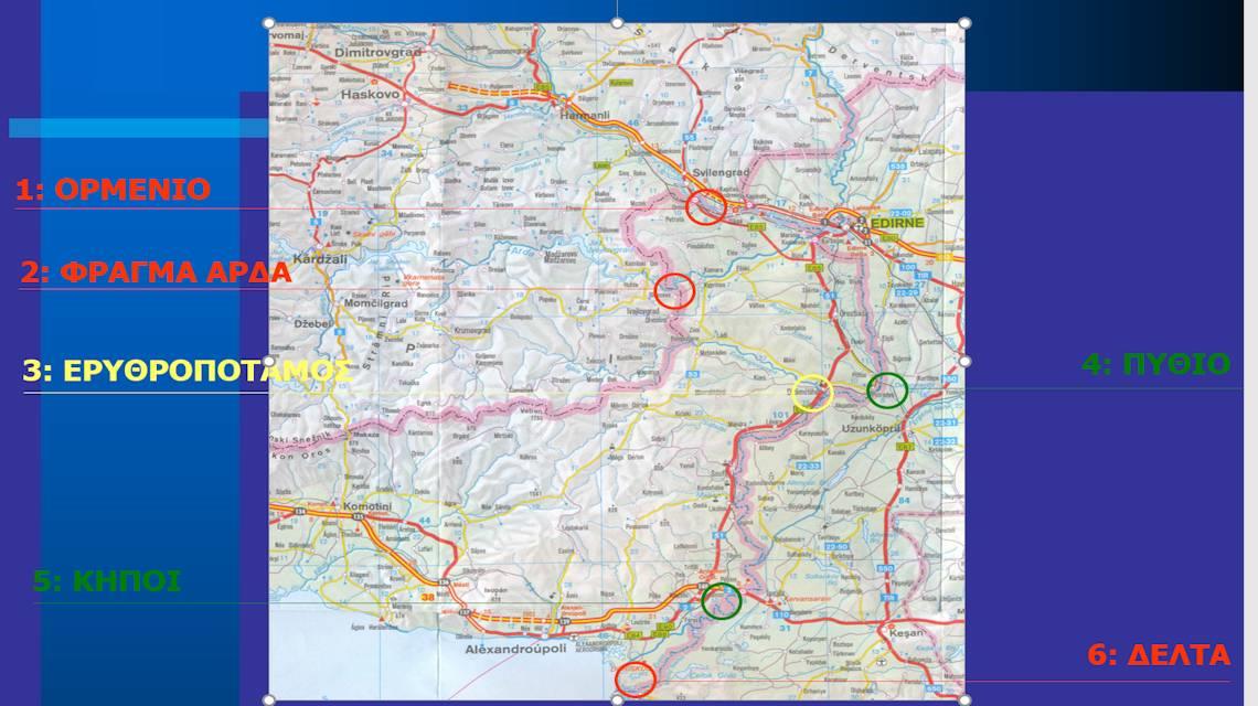
The transboundary catchment of river Evros (Maritsa, Meric) with a catchment of 53,000 km2, is shared between three countries: Greece (6%), Turkey (28%) and Bulgaria (66%). Its main tributaries are Ergene (11000 km2), Tundzha (8500 km2), Ardas (5600 km2) and Erythropotamos (1500 km2). Greece and Turkey are located downstream; hence they suffer the greatest damages when flood flows occur.
There have been few interregional initiatives and agreements that could lead to a more sophisticated water resources management, but unfortunately up until now, the management of the Evros catchment is implemented on a national level, separately for each involved party.
One of the major problems is the numerous hydropower plants located along river Evros and its tributaries. For each hydropower plant there is a dam that alters the hydrological cycle of all the branches and rivers located downstream or upstream. Since most dams were built for the production of hydroelectric power, the operation of the reservoirs is such that the storage level is near its maximum value in order to produce as much energy with as little water flow as possible. Therefore when a flood wave occurs, it is not feasible to decrease the flood flow (routing along the reservoir).
Another critical problem is the huge sediment transport which is caused by extensive erosion upstream. Sediments include rocks and trees and when transported downstream, they alter the cross sections of the river network. Usually the full flow capacity decreases, thus causing more frequent flood problems. This is one of the main reasons why flood problems occur more often in the past few years.
This project aims to monitor the quantitative and qualitative characteristics of the rivers Erythropotamos, Arda and Evros.
View also
This consultancy aimed to organize a complete proposal for the waste treatment installation upgrade.
This is a complete study for modifying flood protection works and for a private port in Waterfront, Navarino, Messinia.
Small stream delineation in Nemea
1/24/2021
Small stream delineation in Nemea according to Laws 1650/1986 and 3010/2002.